
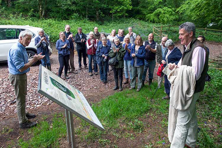
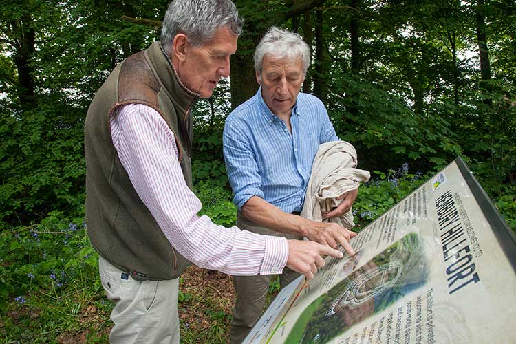
The Lord Lt. of Devon and fellow Hillfort owner, David Fursdon met the team at Colliton Barton Conference Centre, a very well equipped and welcoming facility run by Mr and Mrs McArdle. After a quick cuppa and catch-up the group which included representatives from Blackdown Hills ANOB, Natural England, Historic England, Bournemouth University, Devon Archaeology Society, Ashfords Solicitors, Jim Cawsley (local folk singer), Chris Chapman (photographer and filmmaker), Daniel Jevons, George Greenshields (Ecologist) and family members of the forts owner, all whom have been involved in the recent work to secure the forts future. The group then travelled the short distance up to the fort entrance to watch David Fursdon unveil one of two new information signs recently installed and celebrate what has been achived. After the unveiling by David, we walked up on top of the fort for an excellent breakfast prepared and served by Alan Bruford's Bush Craft Team, which was hugely appreciated. The morning's weather was perfect and the gathering celebrated a new phase of Hembury Fort's history and the securing of its future with the recent work completed.

This years winter works has already managed to open up a new viewing point at the southern end of Hembury Fort looking out towards Dartmoor. On the left of the view you can see the sea east of Budleigh Salterton and to the right Cawsand Beacon on the northernmost edge of Dartymoor! And a long view of the Fosse Way to Exeter, which is why the Romans were up there with a signal beacon. The ramparts are now clearly visible and this latest work revials the scale of them and how impressive they must have been some 3000 years ago.


DCC archaeologist working with the contractor sorting out the parish boundary ditch.
There has been tremendous progress made over the last month to clear Hembury of it's scrub and trees that pose a threat to the earthworks and underlying archaeology. Hartwood Treeworks were contracted to undertake the works and have done a fantastic job on this sensitive site to preserve the archaeology and conserve the environment. Have a scroll through the images above.
Over the spring and summer progress continued at this much loved and nationally important archaeological site, which was first occupied during the Neolithic period, and again in the Iron Age and Roman periods. Funded by a Higher Level Stewardship agreement from Natural England works have included; on-going bracken treatment - which is carefully designed not to impact upon the bluebells; habitat and environmental surveys; and the development of scrub reduction and tree management plans. All these have carefully taken into account the intriguing interim results of the week long geophysical survey carried out by volunteers from Bournemouth University and Devon Archaeological Society earlier in the year.
The approved season for scrub clearance and tree works begun on 1st October and shortly we will see first major phase of work to clear the site of those trees and scrub that pose a threat to the earthworks and underlying archaeology. All the trees have been surveyed for their health and security, and assessed both for their habitat value and for the risk they pose to the archaeology. Every effort is being made to retain significant trees on the site. Please note those trees marked with blue and yellow dots are not earmarked for felling, this was just part of the survey. During the felling and clearance, parts of the site will need to be closed off for public safety. The closed areas may vary on a daily basis, please pay close attention to the posters at the site that will inform you where felling is taking place. Please do not try to access areas where work is clearly taking place.
Although the site may look untidy during the works please be aware that all relevant permissions have been sought and a very careful scheme of works has been designed and is being carried out by people who care deeply about the site and it's future. The work will occur between October and February and we look forward to seeing the views open up and next spring to seeing the grasses and wild flowers take over where scrub and invasive vegetation formerly threatened the site.
The trustees, on behalf of the family, are undertaking a challenging and sensitive project aiming to preserve the archaeology and enhance and conserve the environment of this privately owned site, whilst continuing to welcome those visitors who use the site responsibly. It is hoped that work over the next few years will provide much more information about this important site that will enhance everyone's enjoyment at Hembury. More updates and information will be provided as the project develops.
Hembury Hill fort is a Scheduled Monument and is deemed High Risk on English Heritage's At Risk Register and is recognised as one of the highest priority heritage site for Devon. It is located on the south-west edge of the Blackdown Hills Area of Outstanding Natural Beauty, just north west of Honiton. Hembury Hill fort has been entered into Natural England Higher Level Stewardship (HLS) scheme (agreement AG00630132, start date 1 November 2014). An Archaeological and Conservation Management Plan will be prepared to pinpoint exactly what needs to be completed through the HLS agreement and give the site a long term management direction.
The primary aim of the project, that is to be informed by the Archaeological and Conservation Management Plan, is to reduce the risk to the Scheduled Monument; and through capital works and ongoing management, to reverse the current declining condition trend; initially through establishing an improving condition trend leading eventually to a monument that is at low risk and in a stable condition.
Due consideration of other factors including biodiversity, public access and landscape value should be incorporated at all times.
Whilst the Scheduled Monument is acknowledged to be of National Importance, it is also recognised that further significant archaeological remains will be expected on the wider holding and these too fall within the remit of the Conservation Management Plan together with the other factors mentioned above.
One crucial part of this Archaeological and Conservation Management Plan is that it recognises all of the interests across the site and seeks to integrate the conservation and enhancement of all these interests as well as the management requirements of the archaeology.
To include a condition survey and management plan. The condition survey should describe all archaeological components or items within the HLS area, their archaeological importance, their condition, their current management and any risk factors or threats to the archaeology, and include a plan showing the areas excavated in the 1930s and the 1980s, drawn from the published excavations reports, indicating the depth below surface of deposits in the various areas as shown in the published sections.
This is to identify areas of particular vulnerability to management works where archaeological deposits are near the surface. The management plan should outline the ideal management, any constraints on achieving this and acknowledge any possible impact this management may have on the other interests on the site (including biodiversity habitats and species). The management plan should include maps, plans and method statements for the work proposed in line with required conditions from Natural England, English Heritage or other agencies.
To include a survey and management plan. The surveying must describe the habitats and species present within the HLS area, how these interests are managed at the moment and consider the threats. Particular attention must be paid to European protected species. The management plan must outline the ideal future management, any constraints on achieving this, and acknowledge any possible impact this management may have on the other interests on the site (including archaeology).
To include a tree survey and management plan. The survey must consider the trees over the HLS area with regard to the underlying archaeology. The management plan should outline the management required to the trees such as removal or tree surgery, a method statement for work proposed (including maps). The method statement must take into account the Scheduled Monument and surrounding archaeology and align with the English Heritage standard conditions for scrub and tree work on Scheduled Monument.
To include a scrub survey and management plan. The survey must consider the scrub over the site with regard to the underlying archaeology. The management plan will outline the proposed management action required, a method statement for work proposed. The method statement must take into account the Scheduled Monument and surrounding archaeology and align with the English Heritage standard conditions for scrub and tree work on Scheduled Monument.
Devon Archaeological Society has owned Hembury Fort since September 2022. The Society works with interested and professional parties to ensure that the Scheduled Monument receives the best possible management to preserve the important site for generations to come.
If you need to contact us about anything regarding Hembury Fort please use the email link below.


